
Tag Archives for earthquakes
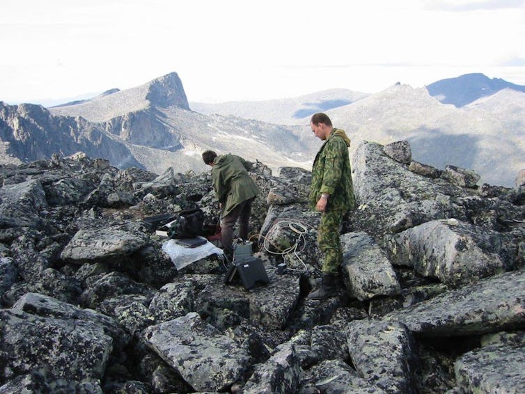
The Great Wall of Japan
Melting ocean mud helps prevent major earthquakes — and may show where quake risk is highest

Shutterstock
Kate Selway, Macquarie University
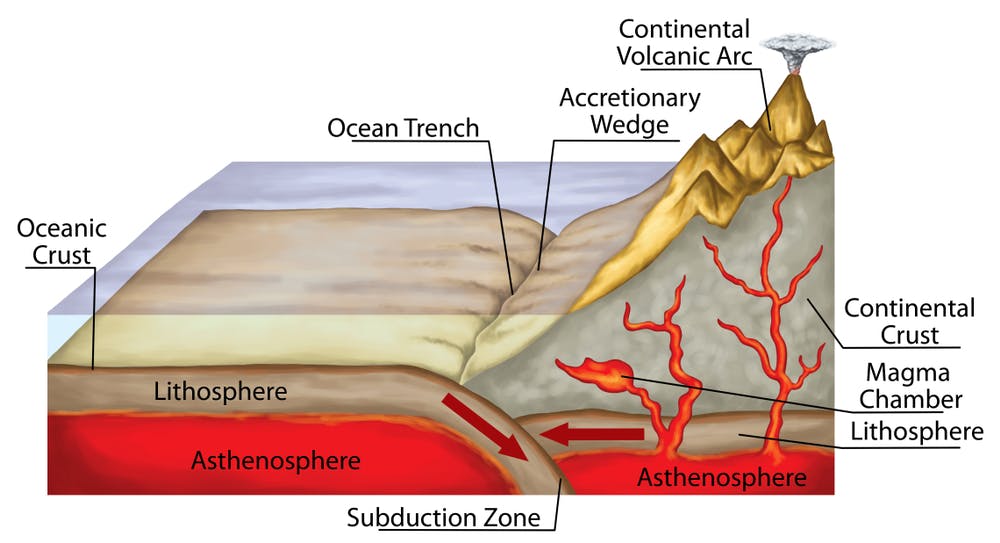
The largest and most destructive earthquakes on the planet happen in places where two tectonic plates collide. In our new research, published today in Nature Communications, we have produced new models of where and how rocks melt in these collision zones in the deep Earth.
This improved knowledge about the distribution of melted rock will help us to understand where to expect destructive earthquakes to occur.
What causes earthquakes?
Giant earthquakes, such as the magnitude-9.0 quake in 2011 that caused the Fukushima nuclear disaster, or the magnitude-9.1 event in 2004 that caused the Boxing Day tsunami, occur at the collision zones between two tectonic plates. In these so-called subduction zones, one plate slides beneath the other.
Read more:
The Fukushima quake may be an echo of the 2011 disaster — and a warning for the future
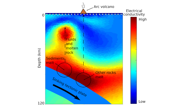
The sinking plate acts as an enormous conveyor belt, carrying material from the surface down into the deep Earth. Earthquakes occur where the sinking plate gets stuck; strain builds up until it eventually quickly releases. Fluids and molten rocks in the system lubricate the plates, helping them slide past each other and stopping big earthquakes from happening.
When happens when ocean mud ends up inside Earth?
My colleague Michael Förster and I were interested in what happens to sediments when they are carried down into the deep Earth at a subduction zone. These sediments start out as thick layers of mud on the ocean floor but get carried down into the deep Earth as part of the sinking plate.
Michael took a sample of mud collected from the ocean floor and heated it up to the high temperatures and pressures it would experience in a subduction zone. He found the sediments melt and then react with the surrounding rocks, forming the mineral phlogopite and also saline fluids.
A puzzle solved
Geophysical models of subduction zones allow us to map out exactly where the molten rocks and fluids are. These measurements are like x-rays of Earth’s interior, helping us peer into places we cannot otherwise see.
We were particularly interested in models of the electrical conductivity of subduction zones. This is because the fluids and molten rock we were looking at are more electrically conductive than the surrounding rock. Models of subduction zones have long been enigmatic, because they show Earth is very conductive in regions where people did not expect to see a lot of fluids and molten rock.
Selway & Forster, Author provided
I calculated the electrical conductivity of the phlogopite, molten sediments and fluids that were produced in the experiments and found they matched extremely well with the geophysical models. This provides good evidence that what we see in the experiments is happening in the real Earth, and allows us to calculate where the molten rock and fluids are in subduction zones around the world.
Understanding where big earthquakes are likely to occur
Giant earthquakes are not likely to occur in the parts of the subduction zone where the sediments melt. All of the products of the melting — the molten rock itself, the saline fluids, and even the mineral phlogopite — help the two plates slide past each other easily without causing large earthquakes.
We compared our models with locations of earthquakes in subduction zones along the west coast of the United States. We found there were no large earthquakes where sediments were melting, but the movement of fluids from the melted sediments could explain some small, non-destructive earthquakes and very faint signals of tremor where the two plates easily slide past each other.
Read more:
Breaking new ground – the rise of plate tectonics
Earthquakes are a tangible reminder that we live on an active planet and that, deep beneath our feet, huge forces are making rocks flow and melt and collide. Accurately predicting earthquakes will be an ongoing goal of geoscientists for decades to come.
It requires intricate detective work to weave together all the tiny threads of information we have about processes that occur so deep in the Earth that we will never be able to see or sample them. Our results are one new thread in this puzzle. We hope it will contribute to one day being able to keep people safe from the risk of earthquakes.
Read more:
Underground sounds: why we should listen to earthquakes
![]()
Kate Selway, , Macquarie University
This article is republished from The Conversation under a Creative Commons license. Read the original article.
How we discovered the conditions behind ‘slow earthquakes’ that happen over weeks or even months – new research
Naeblys/Shutterstock
Åke Fagereng, Cardiff University
You’re probably familiar with earthquakes as relatively short, sharp shocks that can shake the ground, topple buildings and tear rips in the Earth. These earthquakes, and their aftershocks, happen because although tectonic plates move at centimetres per year, this motion is seldom steady. Earthquakes result from a “stick-slip” motion, where rocks “stick” along fault planes while stress accumulates until a “slip” occurs – a bit like pulling on a stuck door until it suddenly opens. This slip also releases energy as the seismic waves that, in large magnitude earthquakes, create substantial damage.
In the last two decades another class of stick-slip motion has been discovered worldwide. These “slow slip events” last for weeks to months, compared to seconds to minutes for earthquakes. Slow slip events occur faster than average plate motion, but too slow to generate measurable seismic waves. This means they need to be studied by GPS networks rather then seismometers.
Although their motion is slow, the amount of movement that occurs in a slow slip event is substantial. Earthquake magnitude depends on the distance that rocks move and the area this movement occurs over. Using the same definition, many slow slip events would have had magnitudes above 7.0 if they slipped at earthquake speeds.
Slow slip events repeat at intervals of a year to a few years. Compared to major earthquakes, which have repeat times of hundreds of years (or more), slow slip events are actually very frequent. Even in the short time of a couple of decades that we’ve observed these types of slip, many cycles have occurred in several places – notably around the Pacific Rim.
Slow slip events generally happen next to areas where faults are locked and expected to rupture in major earthquakes. It’s therefore possible that these slow slip events can trigger earthquakes on neighbouring locked faults. It has, for example, been suggested that slow slip events preceded the 2011 magnitude 9.1 Tohoku earthquake in Japan and the 2014 magnitude 8.1 Iquique earthquake in Chile. That said, numerous slow slip events have also been observed without any immediate, subsequent major earthquakes on neighbouring faults.
Earthquakes may also trigger slow slip. In particular, the magnitude 7.8 Kaikōura earthquake in New Zealand in 2016 triggered slow slip events up to 600km away from its epicentre.
It is not known why some fault segments host slow slip and others host earthquakes. Neither is it known whether the same area can change behaviour and host either slow slip or earthquakes at different times. It’s therefore important to characterise the source of slow slip, and find out what materials help create slow slip and under what conditions.
A unique opportunity
Åke Fagereng composite using map data from NOAA., Author provided
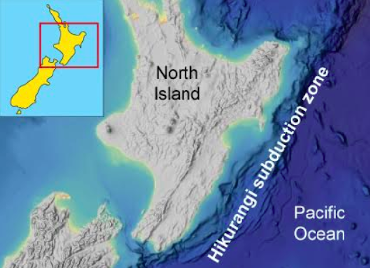
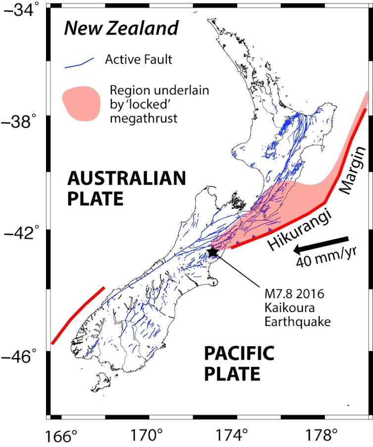
The Hikurangi subduction zone (where the Pacific ocean floor is pulled underneath the New Zealand continent) offshore New Zealand’s North Island is potentially the country’s largest earthquake fault and is a unique opportunity to investigate slow slip events. This is because slow slip here happens shallower and closer to the shoreline than anywhere else in the world.
Åke Fagereng, Author provided
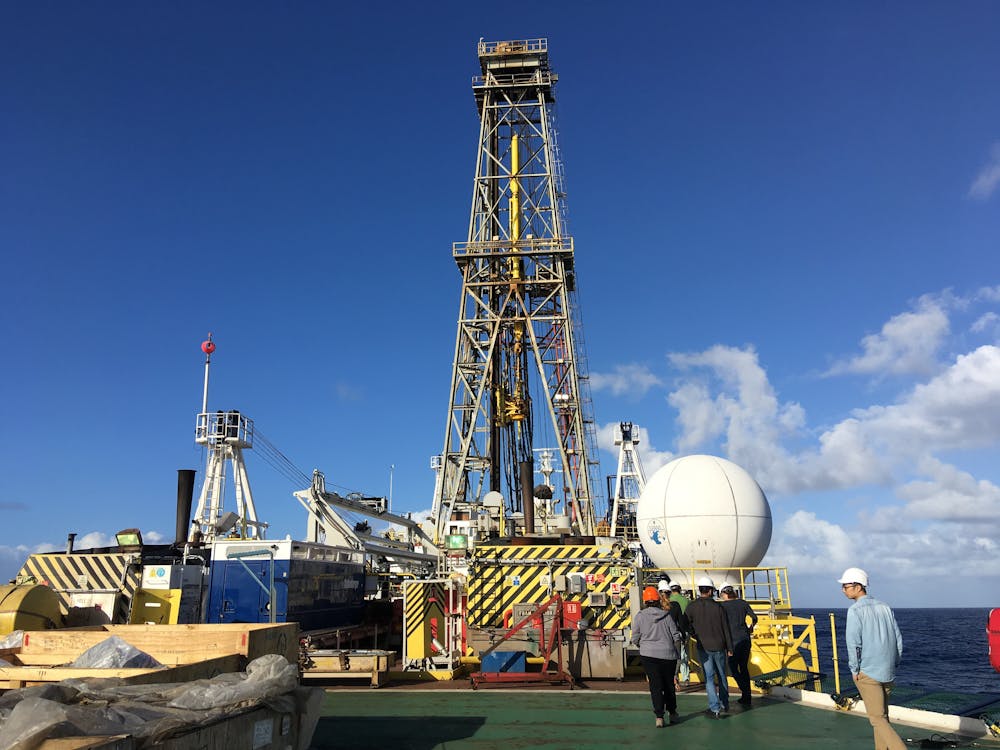
The shallow slow slip events in New Zealand have been observed by onshore GPS and ocean bottom pressure sensors. Oceanic scientific drilling expeditions recently sampled sediments and installed observatories along this margin.
Stihii/Shutterstock
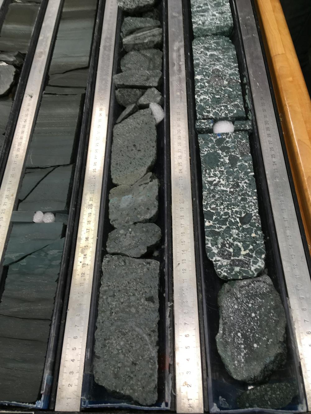
These International Ocean Discovery Program expeditions – which drilled to just over 1km deep in water depths of 3.5km in late 2017 and early 2018 – revealed that the seafloor rocks and sediments hosting slow slip in Hikurangi are extremely variable. The range of rocks, described in a recent Science Advances paper led by Philip Barnes of NIWA (New Zealand’s National Institute of Water and Atmospheric Research), include mudstones, sands, carbonates, and sedimentary deposits from oceanic volcanic eruptions. The seafloor samples show that the source of the slow slip is a mixture of very soft sediment and hard, solid rocks.
Åke Fagereng, Author provided
The diverse seafloor sediments are not the only variability offshore of New Zealand. The seafloor itself is also very rough, including seamounts (submarine mountains rising over a kilometre above the seafloor). This seafloor roughness also makes the fault vary depending on where along it you are.
The observations are consistent with a hypothesis where slow slip events occur in rocks that are transitional between moving steadily and moving in earthquakes. One way to think of this model is as rigid rocks interacting with softer, more ductile surroundings. Researchers using numerical simulations and laboratory experiments have also suggested that variable fault rocks can cause slow slip.
But diverse fault rock isn’t the only model for the mechanics of slow slip. Another possibility is that pressurised fluids decrease frictional resistance and slip speed along faults. It is also possible that some rocks become stronger when they move faster – so that faults start accelerating but slow down before reaching earthquake speeds.
The recent discoveries in New Zealand may be applicable to other depths and locations around the world. However, future studies will undoubtedly lead to further insights and complexities – including in the relationship between slow slip events and earthquakes.![]()
Åke Fagereng, Reader, School of Earth and Ocean Sciences, Cardiff University
This article is republished from The Conversation under a Creative Commons license. Read the original article.
A ‘seiche’ wave can outpace a tsunami, and both can be triggered by meteorites and earthquakes

Leo Roomets / Unsplash, CC BY
Craig O’Neill, Macquarie University
A catastrophic event occurred on Earth 66 million years ago. A huge meteorite struck our planet in what is now Mexico, triggering mass extinctions of the dinosaurs and most other living creatures.
A new paper shows the first recorded victims of this impact were fish and other marine animals, stranded by a wave that left them high and dry in an ancient river in North Dakota, at a site called Tanis.
For scientists unpacking the evidence around the event, a full picture of the cataclysm has involved looking into the details of planetary surface physics during giant impacts.
But beyond the first layer of fascinating results – little glass impact beads stuck in the gills of fish, for example – one really interesting aspect of this work is around how water behaves when it’s exposed to extreme forces.
If you’ve never heard of a form of wave called a seiche, this is your chance to catch up.
Waves of damage
The Chicxulub meteorite crater in coastal Mexico is strongly associated with the mass extinction of the dinosaurs (and 75% of all species), 66 million years ago.
The first victims were right at the site. Any marine creatures close to the point of impact would have been instantly vaporised (sadly leaving no fossil record), along with much of the surrounding rock.
Around the periphery, the energy of the impact melted and ejected tonnes of molten rock, which together with condensing rock vapour, formed little glass beads (“impact spherules”) that can be found in a layer around the world at this time.
The shock wave itself pulverised the adjacent rock enough to metamorphise it, forming features like “shocked quartz” – fractured quartz indicative of enormous pressures. It carried the energy equivalent of a magnitude 11 earthquake – 1,000 times more energy than the 2004 Boxing Day quake which killed almost 230,000 people.
Vast inland sea now gone
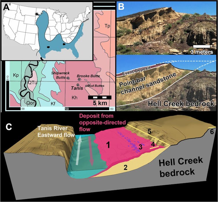
North Dakota is more than 3,000km away from the Chicxulub crater, and was a similar distance at the time of the meteorite impact event.
Separating them back then, however, was a vast inland sea that covered much of midwest USA, from Texas up to the Dakotas. Feeding into that inland sea was a river system upon which the Tanis site in North Dakota was formed. This site has preserved the earliest recorded deaths of the Chicxulub impact.
Robert A DePalma and colleagues
The site itself is unusual. The deposition of sediments can tell us about the flow of water in the river.
Most ripples (or flame structures) indicate a southerly flow of the river before and after the Tanis deposit. However, these flow indicators point the wrong way during the time the Tanis unit formed. Water was flowing upstream, fast.
At the site are also found the fossilised remains of species, like sharks and rays, that occupied brackish water, rather than the freshwater of the stream. These had to be brought inland from the sea by something, and left to die, smothered in sediment, on a riverbank.
Stranded in Dakota
The obvious candidate is an impact tsunami. Perhaps the impact of the meteorite hitting the ocean generated a huge wave that carried fish from the inland sea, and against the flow of fresh water, to leave the creatures stranded in Dakota?
But there are problems with this hypothesis. The tiny impact spherules that formed in Chicxulub can be found throughout the deposit (many clogging the gills of fish), and pockmarks in the sedimentary layers means rocks were still raining down. This means the surge of water occurred within around 15 minutes to two hours of the impact itself.
For a tsunami to travel the 3,000km from the point of impact, to the Tanis site across the inland sea, would have taken almost 18 hours. Something else killed these creatures.
The seismic waves from the impact would have travelled through the Earth much faster than a tsunami travelled across water – and arrived near Tanis between 6-13 minutes later. The authors of the Tanis study suggest these seismic waves may have triggered an unusual type of wave in the inland sea, called a seiche.
Standing waves
Seiches are standing waves in bodies of water, and are often found in large lake systems during strong winds. The winds themselves cause waves and water displacement, which can have a harmonic effect, causing the water to slosh side to side like an overfull bathtub.
However, earthquakes are also known to cause seiches. Particularly dramatic seiches are often seen in swimming pools during large quakes. The interaction of the seismic wave’s period (the time between two waves) with the timescale of waves sloshing in a pool can amplify their effect.
But seiches can affect larger bodies of water too.
During the 2011 Tohuku earthquake in Japan, seiches over 1m high were observed in Norwegian fjords more than 8,000km away. With an energy more than 1,000 times greater, the Chicxulub event could quite conceivably have generated bigger than 10 metre swells in the North American inland sea – the scale implied by the deposition of the Tanis site.
Given a seiche can be driven by seismic waves, it’s conceivable that one drove the surge that stranded marine creatures at Tanis, resulting in the short time between the impact debris and the surge deposit.
Still lots of questions
But a lot remains unclear regarding exactly what did happen 66 million years ago.
Could the fish stranding have been driven by the first seismic activity to appear at Tanis (the P and S waves in science parlance, which travel through the interior of the Earth, arriving at Tanis 6 and 10 minutes after impact, respectively), or the more destructive but slower surface waves at the top of the Earth’s crust, which arrived 13 minutes after impact?
How might seiche waves have interacted with global hurricane-strength wind storms caused by the impact?
Would the period of sloshing of a seiche be consistent with the scale of the inland sea? (The inland sea was much larger than most lakes seiches are traditionally observed in – and may or may not have been open to the ocean). Given so little is really known about the dimensions of the inland sea, this is hard to constrain.
The Tanis site has given us an incredible window into the first few hours of a mass-extinction. But it has also highlighted how little we have probed into the fatal surface physics of these extreme events.![]()
Craig O’Neill, Director of the Macquarie Planetary Research Centre/Associate Professor in Geodynamics, Macquarie University
This article is republished from The Conversation under a Creative Commons license. Read the original article.
Earthquakes Are Hard to Predict
Satellite measurements of slow ground movements may provide a better tool for earthquake forecasting
Simon Lamb, CC BY-ND
Simon Lamb, Victoria University of Wellington
It was a few minutes past midnight on 14 November 2016, and I was drifting into sleep in Wellington, New Zealand, when a sudden jolt began rocking the bed violently back and forth. I knew immediately this was a big one. In fact, I had just experienced the magnitude 7.8 Kaikoura earthquake.
Our research, published today, shows how the slow build-up to this earthquake, recorded by satellite GPS measurements, predicted what it would be like. This could potentially provide a better tool for earthquake forecasting.
Read more:
New Zealand’s Alpine Fault reveals extreme underground heat and fluid pressure
Shattering the landscape
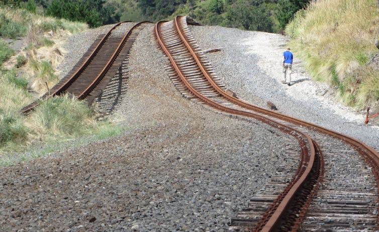
The day after the quake, I heard there had been huge surface breaks in a region extending for more than 170 km along the eastern part of the northern South Island. In some places, the ground had shifted by 10 metres, resulting in a complex pattern of fault ruptures.
In effect, the region had been shattered, much like a fractured sheet of glass. The last time anything like this had happened was more than 150 years ago, in 1855.
Quite independently, I had been analysing another extraordinary feature of New Zealand. Over the past century or so, land surveyors had revealed that the landscape is moving all the time, slowly changing shape.
These movements are no more than a few centimetres each year – but they build with time, relentlessly driven by the same forces that move the Earth’s tectonic plates. Like any stiff material subjected to excessive stress, the landscape will eventually break, triggering an earthquake.
I was studying measurements made with state-of-the-art global positioning system (GPS) techniques – and they recorded in great detail the build-up to the 2016 Kaikoura earthquake over the previous two decades.
A mobile crust
GPS measurements for regions at the edges of the tectonic plates, such as New Zealand, have become widely available in the last 15 years or so. Here, the outer part of the Earth (the crust) is broken up by faults into numerous small blocks that are moving over geological time. But it is widely thought that even over periods as short as a few decades, the GPS measurements still record the motion of these blocks.
Simon Lamb, CC BY
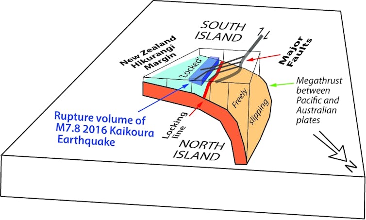
The idea is that at the surface, where the rocks are cold and strong, a fault only moves in sudden shifts during earthquakes, with long intervening periods of inactivity when it is effectively “locked”. During the locked phase, the rocks behave like a piece of elastic, slowly changing shape over a wide region without breaking.
But deeper down, where the rocks are much hotter, there is the possibility that the fault is slowly slipping all the time, gradually adding to the forces in the overlying rocks until the elastic part suddenly breaks. In this case, the GPS measurements could tell us something about how deep one has to go to reach this slipping region, and how fast it is moving.
From this, one could potentially estimate how frequently each fault is likely to rupture during an earthquake, and how big that rupture will be – in other words, the “when and what” of an earthquake. But to achieve this understanding, we would need to consider every major fault when analysing the GPS data.
Invisible faults
Current earthquake forecasting “reverse engineers” past distortions of the Earth’s surface by finding all the faults that could trigger an earthquake, working out their earthquake histories and projecting this pattern into the future in a computer model. But there are some big challenges.
The most obvious is that it is probably impossible to characterise every fault. They are too numerous and many are not visible at the surface. In fact, most historical earthquakes have occurred on faults that were not known before they ruptured.
Our analysis of the GPS measurements has revealed a more fundamental problem that at the same time opens new avenues for earthquake forecasting. Working with statistician Richard Arnold and geophysicist and modeller James Moore, we found the GPS measurements could be better explained if the numerous faults that might rupture in earthquakes were simply ignored. In other words, surface faults seemed to be invisible when looking at the slow movements recorded by GPS.
There was only one fault that mattered – the megathrust that runs under much of New Zealand. It separates the Australian and Pacific tectonic plates and only reaches the surface underwater, about 50 to 100km offshore. Prior to the Kaikoura earthquake, the megathrust was locked at depths shallower than about 30km. Here, the overlying Australian plate had been slowly changing shape like a single piece of elastic.
Simon Lamb, CC BY
The pacemaker for future quakes
In the conventional view, every big fault has its own inbuilt earthquake driver or pacemaker – the continuously slipping part of the fault deep in the crust. But our analysis suggests that these faults play no role in the driving mechanism of an earthquake, and the pacemaker is the underlying megathrust.
We think the 2016 Kaikoura earthquake provides the vital clue that we are right. The key observation is that numerous ruptures were involved, busting up the boundary between the two plates in a zone that ran more-or-less parallel to the line of locking on the underlying megathrust. This is exactly what we would anticipate if the slow build-up in stress was only driven by slip on the megathrust and not the deeper parts of individual crustal faults.
I remember once watching a documentary about the making of the Boeing 777 aircraft. The engineers were very confident about its design limits under flying conditions, but the Civil Aviation Authority wanted it tested to destruction. In one test, the vast wings were twisted so that their tips arced up to the sky at a weird angle. Suddenly, there was a bang and the wings snapped, greeted by loud cheering because this had occurred almost exactly when predicted. But the details of how this happened, such as where the cracks of metal fatigue twisted the metal, were something that only the experiment could show.
I think this is a good analogy for realistic goals with earthquake prediction. The Herculean task of identifying every fault and its past earthquake history may be of only limited use. In fact, it is becoming clear that earthquake ruptures on individual faults are far from regular. Big faults may never rupture in one go, but bit by bit together with many other faults.
But it might well be possible to forecast when there will be severe shaking in a region near you – surely something that is equally as valuable.![]()
Simon Lamb, Associate Professor in Geophysics, Victoria University of Wellington
This article is republished from The Conversation under a Creative Commons license. Read the original article.
The science of landslides, and why they’re so devastating in PNG
US Geological Survey
Benjy Marks, University of Sydney
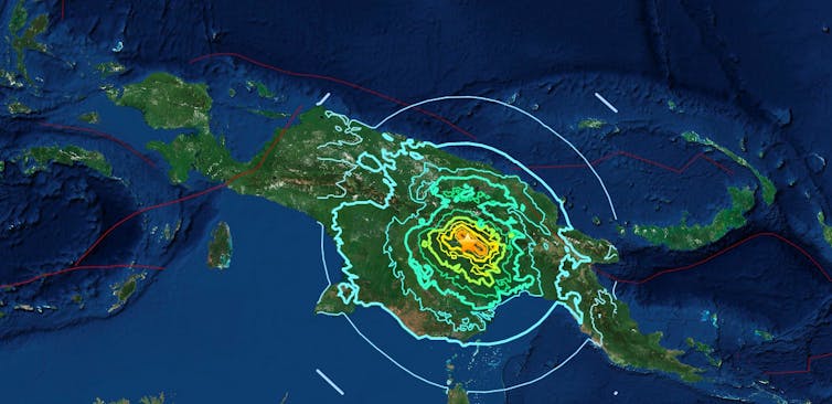
A magnitude 7.5 earthquake struck the Southern Highlands region of Papua New Guinea on February 25, 2018. This was followed by a series of aftershocks, producing widespread landslides that have killed dozens and injured hundreds. The same landslides have cut off roads, telecommunications and power to the area.
//platform.twitter.com/widgets.js
The PNG government has declared a state of emergency in the region. There is growing concern over several valleys that have been dammed by landslides and are beginning to fill with water – now ready to collapse and surge downstream, directly towards more villages.
Why is Papua New Guinea so susceptible to landslides? It’s a combination of factors – steep terrain, earthquakes and aftershocks plus recent seasonal rains have created an environment that is prone to collapse.
Read more:
Five active volcanoes on my Asia Pacific ‘Ring of Fire’ watch-list right now
How land becomes unstable
The Earth around us is generally pretty stable, but when the ground shakes during an earthquake it can start to move in ways we don’t expect.
Pressure changes during an earthquake create an effect in the soil called liquefaction, where the soil itself acts as a fluid.
When lots of water is present in the soil, as is the case now during the monsoon season in Papua New Guinea, liquefaction can happen even more easily.
When liquefaction occurs, the earthquake creates changes due to friction. Imagine a visit to the greengrocer, where an accidental bumping of a carefully stacked pile of apples can cause cause them all to suddenly collapse. What was holding the pile together was friction between the individual apples – and when this disappears, so does the pile.
In an earthquake, two tectonic plates slip past one another deep underground, rubbing together and cracking the nearby rocks. The effects of this movement up at the surface can vary depending on the nature of the earthquake, but one feature is fairly common: small objects bounce around. The sand grains just below the surface do the same thing, but a bit less excitedly. A few metres down, grains could be bouncing around just enough to lose contact with each other, removing the friction, and becoming unstable.
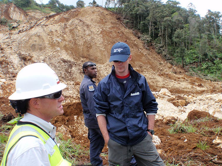
dfataustralianaid/flickr, CC BY
Things are normally stable because they’re sitting on top of something else. When that support suddenly disappears, things tend to fall down – this is the classic dodgy folding chair problem experienced by many.
In engineering, we call this “failure” – and in the building industry it usually occurs immediately before the responsible engineer receives a call from a lawyer. Mechanically, this failure happens when the available friction isn’t enough to support the weight of the material above it.
Read more:
Explainer: after an earthquake, how does a tsunami happen?
When soil acts like fluid
Once a slope fails, it starts to fall downhill. If it really slides, then we’re back to the same situation of grains bouncing around. Now, none of the grains are resting against each other, and the whole thing is acting like a fluid.
A couple of interesting things happen at this point. First, as the grains are bouncing around, small particles start to fall through all the newly formed holes that have opened up. This occurs for the same reason that you find all the crumbs at the bottom of your cereal box, and all of the unpopped kernels at the bottom of your bowl of popcorn. Once these smaller fragments accumulate at the bottom of the flowing landslide, they can help it slide more easily, accelerating everything and increasing its destructive power.
Second, landslides typically flow faster at the surface than below, so as large particles accumulate at the top they are also the ones moving the fastest, and they start to collect at the front of the landslide. These large particles, often boulders and trees, can be incredibly damaging for any people or structures in their path.
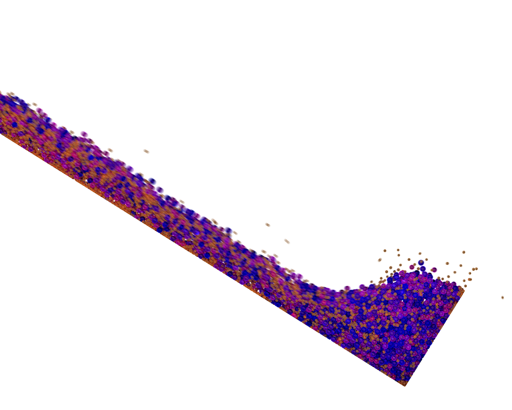
Benjy Marks/USyd
The image above shows a laboratory simulation of a landslide flowing down a slope and hitting a fixed wall. The spherical particles are coloured by size (small is yellow; large is blue). Data from these sorts of studies can help predict the forces that an object will feel if it gets hit by a landslide.
Watching and waiting
These complex dynamics mean that we really need to know a lot about the geography and geology of a particular slope before any kind of reliable prediction could be made about the behaviour of a particular landslide.
In the remote areas of Papua New Guinea, accumulating this data at every point on every slope is a tough challenge. Luckily, huge advancements have recently been made in remote sensing, so that planes and satellites can be used to extract this vital information.
Using sophisticated sensors, they can see past foliage and map the ground surface in high resolution. As satellites orbit quite regularly, small changes in the surface topography can be monitored. Scientists hope that by using this information, unstable regions that haven’t yet failed can be identified and monitored.
Read more:
Controversial artist Elizabeth Durack gave us a sensitive insight into the lives of Papuan women
Papua New Guinea is located on an active fault line and has had nine major earthquakes in the past five years. Combined with the often remote and steep terrain, together with a monsoon season that delivers repeated heavy rainfall events, it is a particularly active area for landslides to develop.
![]() The dry season in Papua New Guinea will not arrive until June. During the current wet season we may see even more slopes fail due to destabilisation by the recent earthquakes.
The dry season in Papua New Guinea will not arrive until June. During the current wet season we may see even more slopes fail due to destabilisation by the recent earthquakes.
Benjy Marks, Lecturer in Geomechanics, University of Sydney
This article was originally published on The Conversation. Read the original article.
I’ve always wondered: do nuclear tests affect tectonic plates and cause earthquakes or volcanic eruptions?
The Official CTBTO Photostream (Copyright CTBTO Preparatory Commission) , CC BY
Jane Cunneen, Curtin University
This is an article from I’ve Always Wondered, a new series where readers send in questions they’d like an expert to answer. Send your question to alwayswondered@theconversation.edu.au
Do underground nuclear tests affect Earth’s tectonic plates, and cause earthquakes or volcanic eruptions? – Anne Carroll, Victoria
Apart from escalating global fears about conflict, North Korea’s recent nuclear tests have raised questions about geological events caused by underground explosions.
Some media reports suggest the tests triggered earthquakes in South Korea. Others report the explosions may trigger a volcanic eruption at Paektu Mountain, about 100km from the test site.
So can an underground test cause an earthquake? The short answer is yes: a nuclear explosion can cause small earthquakes. But it is unlikely to affect the earth’s tectonic plates or cause a volcanic eruption.
Although a nuclear explosion releases a lot of energy in the immediate region, the amount of energy is small compared to other stresses on tectonic plates.
Read more: What earthquake science can tell us about North Korea’s nuclear test
What are tectonic plates?
Tectonic plates are slabs of the earth’s crust which move very slowly over the surface of the earth. Mountain ranges form at the edges of the plates when they collide, and ocean basins form when they move apart.
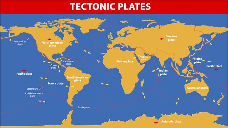
Designua/shutterstock
Volcanoes occur mostly where plates are colliding. One plate overrides another, pushing it down to where it may partly melt. The partially melted rock – also known as lava – then rises to the surface, causing a volcano.
The movement of tectonic plates also causes earthquakes, which is why 90% of them occur at the plate boundaries. All but the deepest earthquakes occur along faults, which are breaks in the crust where rocks can move past each other in response to stress. This stress can be from both natural events and human activities.
Human induced earthquakes
“Induced seismicity” is the term used to describe earthquakes caused by human activities.
Human induced earthquakes can be caused by anything that changes the stresses on rocks beneath the surface. These include processes that add or remove great loads from the surface, such as mining, building dams or tall buildings.
Other processes that change the amount of pressure on rocks can include fluid injection from drilling, or extraction of water from aquifers.
Human-induced earthquakes have been reported from every continent except Antarctica. Induced earthquakes only occur where there is already some stress on the rocks. The human activity adds enough stress to the rocks to reach the “tipping point” and trigger the earthquake.
Nuclear explosions can induce small earthquakes along existing faults near a test site. Some underground nuclear tests have fractured the ground surface above the explosions, causing movement on faults adjacent to explosion sites.
Earthquakes from nuclear testing
The 3 September 2017 North Korean nuclear test generated shock waves equivalent to a magnitude 6.3 earthquake. Eight minutes later, a magnitude 4.1 event was detected at the same site. This may have been linked to a collapse of a tunnel related to the blast.
Several small earthquakes measured since the event may have been induced by the nuclear test, but the largest is only a magnitude 3.6. An earthquake of this size would not be felt outside of the immediate area.
Read more: North Korea tests not just a bomb but the global nuclear monitoring system
The largest induced earthquake ever measured from nuclear testing was a magnitude 4.9 in the Soviet Union. An earthquake of this size can cause damage locally but does not affect the full thickness of the earth’s crust. This means it would not have any effect on the movement of tectonic plates.
Historical data from nuclear testing (mostly in the USA) shows that earthquakes associated with nuclear testing typically occur when the explosion itself measures greater than magnitude 5, 10–70 days after the tests, at depths of less than 5km, and closer than around 15km to the explosion site. More recent studies have concluded that nuclear tests are unlikely to induce earthquakes more than about 50km from the test site.
Volcanic eruptions
Concerns have also been raised about the risk of volcanic eruptions induced by the nuclear tests in North Korea. Paektu Mountain is about 100km from the test site and last erupted in 1903.
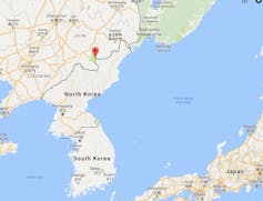
Google Maps
In the 1970s, the USA conducted a number of nuclear tests in the Aleutian Islands, a volcanic island arc chain containing 62 active volcanoes.
One of the blasts, named Cannikin, was the largest underground nuclear test ever conducted by the USA. There were fears that the blast would cause a huge earthquake and tsunami. The blast did result in some induced earthquakes, but the largest was a magnitude 4.0 and there was no increase in volcanic activity.
Based on this evidence, it seems unlikely a nuclear test by North Korea will trigger an eruption of Paektu Mountain. If the volcano was on the verge of erupting, then an induced earthquake from a nuclear blast could influence the timing of the eruption. However, given the distance from the test site then even this is not likely.
Monitoring nuclear tests
The Comprehensive Nuclear Test Ban Treaty Organisation (CTBTO) has a global monitoring system to detect nuclear tests, including seismometers to measure the shock waves from the blast and other technologies.
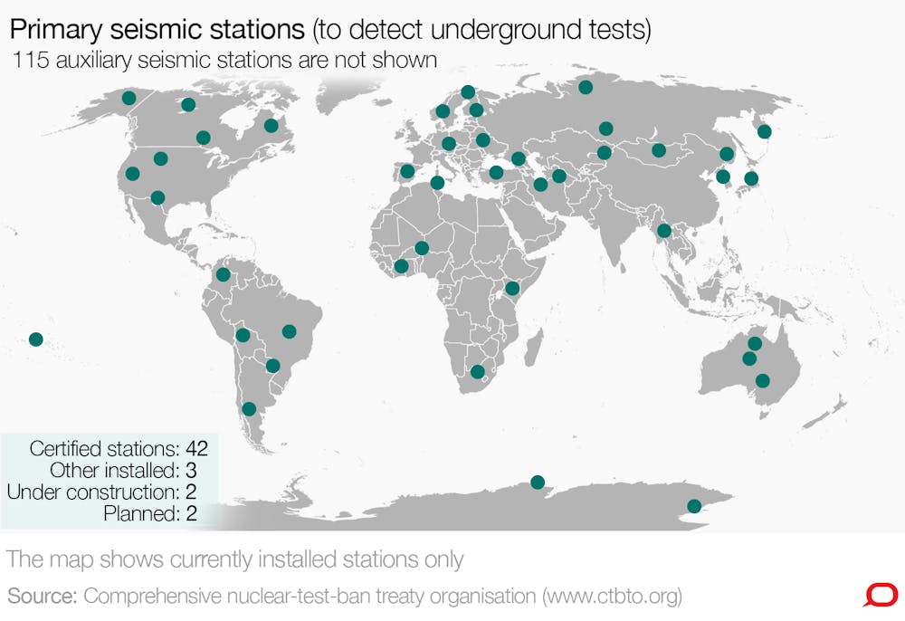
CTBTO / The Conversation, CC BY-NC-ND
Seismologists can analyse the seismic data to determine if the shock waves were from a naturally occurring earthquake or a nuclear blast. Shock waves from nuclear blasts have different properties to those from naturally occurring earthquakes.
Testing was much more common before the CTBTO was formed: between 1945 and 1996 more than 2,000 nuclear tests were conducted worldwide, including 1,032 by the USA and 715 by the Soviet Union.
![]() Since 1996 only three countries have tested nuclear devices: India, Pakistan and North Korea. North Korea has conducted six underground nuclear tests at the same site between 2006 and 2017.
Since 1996 only three countries have tested nuclear devices: India, Pakistan and North Korea. North Korea has conducted six underground nuclear tests at the same site between 2006 and 2017.
Jane Cunneen, Research Fellow, Curtin University
This article was originally published on The Conversation. Read the original article.
Fracking and Earthquakes

You must be logged in to post a comment.